gpx2img

Converting your GPX files to Garmin IMG Files

Buy Now

Multi-map product preview

Wow! Was it really almost a month ago I published the last blog about my current plans for gpx2img? Hard to believe.

Well, as promised I’ve got a preview of the multiple map product support that has been requested by so many of you. As mentioned, this will allow you to split your maps into separate items in the Mapsource drop-down menu. So for example, you can have one mapset containing your logging roads, one with your hiking trails, one with your sledding trails and one with your off-roading trails. This will make it much easier to choose the type of tracks you want to upload depending on the season, etc and also allow you better control on the GPS itself which maps are displayed (you can turn on/off whole mapsets on most Garmin GPS units).

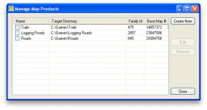
Mapset Manager

The Mapset Manager allows you to add/remove and edit the mapsets you create. Allows you to set the family ID and base map number for the mapset you create.

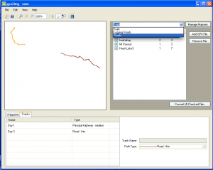
Mapset drop-down

Added a new drop-down menu above the gpx file listing allowing you to choose which mapset you are working on and add/remove gpx files that mapset.

There is still work to be done on the conversion side of the program and details to clean up. Especially making it fully compatible with TYP files which are tied to a single family ID. So I will need to dynamically change the TYP file to make it work with any/all of the mapsets.

Another big change that was easiest to include with the above changes is the ability to save mapsets and gpx files into a single file called a ‘g2i’ file. Now rather than working directly on the GPX files on your computer, gpx2img will load them into it’s own local copy and work on them there. A huge benefit of this for many users will be the ability to send the g2i file to anyone with gpx2img and they can open it with all changes and just hit the convert button. This will make sharing your maps with others much simpler! (There are a few other possibilities that this also creates, but I’ll leave those for the future..)

So that was the preview of multiple mapsets in gpx2img. I hope to have this released in a couple weeks, but make no promises.
What do you think? Will it be a useful feature? How do you envision using the new features discussed above? Leave a comment and let me know!

UPDATE – March 31, 2011 Obviously I’m a bit behind in my planned schedule for this feature. Other aspects of my business have taken over much of the time I was spending on gpx2img. I aim to have more time to work on gpx2img in April and will hopefully be able to get a new version with the feature out the door soon. Thanks for your patience!

Development Status

So if you’re checking out this blog, I’m going to assume you’re interested in what is the latest with gpx2img.. Well, here is a little preview of my current development plans..

Next major update: -Support for managing multiple map products (Check back soon for a preview!).
This is one of the features I’ve received the most request for since releasing gpx2img (and from my beta testers before that). Right now (version 1.0.5.2) gpx2img allows you to use a single mapset. You add your gpx files, click convert, and your maps appear in Mapsource under the “GPX2IMG Map” mapset.
This is fine if you’re just converting maps from the same area and for the same activity. But if you want to make a set of maps for your ATVing in the summer and sledding in the winter, it gets more complicated to manage.
(Also I’m told the newer Garmin Oregon units don’t allow users to turn off individual map tiles, just map products as a whole which is inconvenient)

Multiple mapset managing will allow you to have multiple map products in gpx2img which you can add your GPX files to and each mapset will appear in Mapsource on its own (and you’ll be able to define custom target directories, FIDs and base map names for each mapset.

Future Plans:
-Better TYP file support. (Be able to load and use any custom lines in TYP files, not just the predefined lines gpx2img looks for now).
-Ability to read other file formats (and also load routes from GPX files).

On the todo list
And at some point I’ll be replacing the DLL gpx2img uses for generating its IMG files. Currently it uses cgpsmapper, but it has been announced this product will no longer be updated. It will be a major undertaking to replace the IMG file creation code with a custom solution, but it will be done..

And of course there are numerous other bug fixes and smaller updates planned between these items..

A big one I’m working on is supporting non-latin characters for track and POI names in the IMG files.. I’m hoping to get this working soon, but it may have to wait until I rewrite the IMG creation code as mentioned above..

Have any other suggestions for gpx2img? Want to see any feature given higher priority? Comment here or email me at joel@gpx2img.com!

Bloggin time!

Hello everyone!

I hate as much as the next person purchasing or being interested in some software/service/widget/etc and checking their website regularly and not being able to find out what is going on.. For any software I use regularly and like to keep up to date, I always add their RSS feed to my blog reader so I can find out what is going on.

I’m sure (or at least I hope) there are some people out there who use GPX2IMG and would like to be kept up to date with what is going on in the world of gpx2img. This will be the place where I’ll be communicating that!

So add this RSS feed to your favorite RSS reader and stay tuned!